|
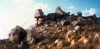
The Society to Save Rocks has published a Wall Calendar with photographs of Heritage Rock Sites in Hyderabad. It covers all 23 Heritage Rock Precincts notified under the Heritage Regulations of the Government of (erstwhile) Andhra Pradesh by the Hyderabad Metropolitan Development Authority HMDA, in 1998 and 2009. The Telangana Tourism Department has kindly sponsored its publication.
The Calendar is meant to raise the awareness of citizens and the government officials as to the Heritage status of these rock areas, apart from bringing to you images of the astounding rock formations which still exist in Hyderabad and are protected by government regulation. It lists the locations of these rock areas with Survey Nos. etc. at the bottom of each page. If you would like to visit these rocks, you could find the location maps below. The size of the calendar is 13.5"x17".
Apart from distributing the calendars to government departments, they have been put up for sale. They can be obtained from both bookshops of Walden and from Akshara in Hyderabad, or from the Society's office. Price is Rs. 200 per copy. Please contact the office at 04023552923 / 9849936248.
View 2015 Calendar of Heritage Rock Precincts in Hyderabad/Deccan.
-----------------------------------------------------------------------------------------------------------------------
Here some more details of official and private initiatives to preserve the rocks of Hyderabad:
Official Initiatives
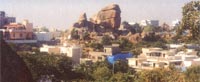
The Government must play an important role in the preservation of the Deccan's stunning granite formations. The Government of erstwhile Andhra Pradesh has taken the first step by including rock areas in Regulation No. 13 of the Hyderabad Urban Development Authority(HUDA) for the protection of Heritage Buildings and Precincts. Hyderabad is the only city in India where rocks are protected as a natural heritage. Hyderabad Metropolitan Development Authority HMDA (successor organization of HUDA), the Municipal Corporation and the Tourism Department have already started to develop rock gardens in the city.
The first 9 Formations proposed by the Soiety in 1997 and protected under Regulation 13 of the Hyderabad Urban Development Authority Zoning Regulations 1981 are as follows:
1. |
 |
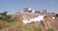
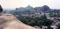
"Hillocks around Durgam Cheruvu", a lake situated between Jubilee Hills and Hitec City.
Beautiful lake between the new Hitec development and the
rocks of Jubilee Hills; best viewing from Durgam Cheruvu
Lake Resort near Ambedkar Open University. Walking and
climbing in the rocky parts around the lake from the
footpath that leads around the lake.
Coordinates (Plaque): 17°25'47" N 78°23'30" E
Enlarge view | Route map |
| 2. |
|
"Rock Park" near Khajaguda, Nanakramguda Road
This area has been fully built over by the Cineworkers Housing Colony; only the front ridge is preserved as " Rocky Ridge behind Malkam Cheruvu " (see 2nd group, No. 15) "
Coordinates: 17°26'56.17" N 78°22'42.08" E
Route map |
| 3. |
 |
"Bear's Nose", now surrounded by Hotel "Trident", behind Cyber Tower, Hitec City.
Single formation surrounded by hotel building site; visible from Rock Heights Function Park.
Coordinates: 17°26'56.17" N 78°22'42.08" E
Enlarge view | Route map |
| 4. |
 |
"Mushroom Rock", Formation in the campus of Central University of Hyderabad, Gachibowli.
Famous single formation; access through University of Hyderabad for the initiated;
Coordinates:17°26'30.10" N 78°20'20.78" E
Enlarge view | Route map |
| 5. |
 |
"Cliff Rock", Hillock in Road No. 46, Jubilee Hills.
No access because of new constructions around the rocks.
Coordinates: 17°25'54.17" N 78°23'56.41" E
Enlarge view | Route map |
| 6. |
 |
"Monster Rock", Formation in Road No. 71, Jubilee Hills.
Single formation, no access, good view from Nandagiri Hills and Road no. 71 Jubilee Hills.
Coordinates: 17°25'16.93" N 78°24'24.12" E
Enlarge view | Route map |
| 7. |
 |
"Tortoise Rock", Formation in B.N.R.Hills, near Durgam Cheruvu.
Beautiful single formation, preserved in a road island; worth a visit.
Coordinates: 17°25'27.10" N 78°23'43.46" E
Enlarge view | Route map |
| 8. |
 |
"Toadstool", Formation in Road No. 35, Jubilee Hills.
Access only for avid boulderers, undeveloped bouldering
area behind Blue Cross.
Coordinates: 17°26'26.76"N 78°24'12.21"E
Enlarge view | Route map |
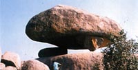
| 9. |
 |
"Obelisk", Formation in Road No. 66, Jubilee Hills.
Small single formation on Sidewalk.
Coordinates: 17°25'37.63" N 78°24'36.18" E
Enlarge view | Route map |
-----------------------------------------------------------------------------------------------------------------------
The Society has again proposed a list of 20 Rock Sites to be notified under the HUDA Heritage Regulations, on 22 May 2006. Out of these sites, 15 have been notified as Heritage Precincts by the Government of AP, G.O. 68, on 3rd Feb, 2009:
1. |
|
Rock on which Baba Fakhruddin Aulia's Dargah is situated, Poppalguda.
Extensive sheet rock with historical dargah of the saint
Baba Fakhruddin Aulia; in the vicinity of Hitec City; good
possibilities for walking, climbing, bouldering; highly
recommended for rock outings.
Coordinates (dargah): 17°24'37" N 78°21'58" E
Enlarge view | Routemap |
| 2. |
 |
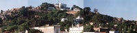
Rocks at Maula Ali's Dargah, Maula Ali.
Big rock dome with famous historical Dargah, access by flight of steps, not much scope for walking and climbing, but worth a visit for the view from the top; two smaller rock domes close by, accessible by steep steps
Old Gateway on the main road closed to traffic at the moment, take diversion to the right around it.
Coordinates: 17°28'06.35" N 78°33'24.73" E
Enlarge view | Routemap |
| 3. |
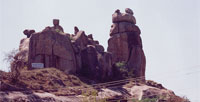 |
"Sentinel Rock", near Maula Ali.
Single formation with a few surrounding boulders, good for short climb.
Coordinates: 17°27'32.14" N 78°33'15.16" E
Enlarge view | Routemap |
| 4. |
 |
"Skull Rock", Hitec City Phase II.
Single formation behind Hotel "Lemon Tree". Access through parking area of the hotel.
Coordinates: 17°26'36.05" N 78°22'33.89" E
Enlarge view | Routemap |
| 5. |
 |
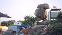
"Hamburger Rock", near Telecom Nagar, Gachibowli.
Impressive single formation; access only through NITHM Compound.
Coordinates: 17°25'49.10" N 78°21'47.92" E
Enlarge view | Routemap |
| 6. |
 |
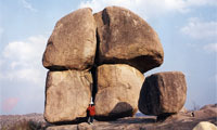
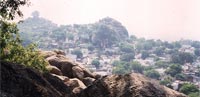
Rock on which Dargah Pahar-e-Shareef is situated
Extensive hill with historical dargah; impressive formations
mostly in dargah; appr.15 km south of Charminar.
Coordinates (dargah): 17°16'02.79" N 78°28'18.54" E
Enlarge view | Routemap |
| 7. |
 |
United-We-Stand Rock Gachibowli.
Single formation; access only through Urdu University.
Coordinates: 17°25'17.32" N 78°22'12.84" E
Enlarge view | Routemap |
| 8. |
 |
Pathar Dil Rock, Gachibowli.
Single formation; access through Urdu University.
Coordinates: 17°25'23.61" 78°22'12.86" E
Enlarge view | Routemap |
| 9. |
 |
Rock on which Dattatreya Temple is situated, Asif Nagar.
Access to the temple by steps, good view of city, difficult to find access in densely populated area.
Coordinates: 17°23'05.94" N 78°27'11.76" E
Enlarge view | Routemap |
| 10. |
 |
Allabanda Hill, Sitaram Bagh.
Extensive hill with a few good rock formations, from the north difficult to find access in densely populated area, ask locals; access from the south via Gangabowli;
for general orientation see also Dattatreya sketch.
Coordinates: 17°22'48.89"N 78°27'16.05"E
Enlarge view | Routemap |
| 11. |
 |
Gangabowli-ka-Pahar, Gangabowli.
Small steep path from Lodh Bhavan to hill top;
for general orientation see also Dattatreya sketch.
Coordinates: 17°22'41.51"N 78°27'22.76"E
Enlarge view | Routemap |
| 12. |
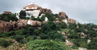 |
Rocks around Dargah Ghar-e-Mubarak etc., near Taramati Baradari.
Moslem prayer hall inside the rocky ridge; behind Taramati
Baradari, impressive formations; access from Royal Function Hall on Gandipet Road by jeepable road or from Hyder Shakot by jeepable road, from Hyder Shakot partly
asphalted road; good walking and climbing possibilities.
Coordinates (Dargah): 17°22'11.26" N 78°22'03.96" E
Enlarge view | Routemap |
| 13. |
 |
Rocks around Piran Shah Wali Dargah, near AP Police Academy.
Small but impressive rock site with ancient dargah and
small mosque; not much walking and climbing possibilities.
Coordinates (Dargah): 17°21'18.28" N 78°22'05.32" E
Enlarge view | Routemap |
| 14. |
 |
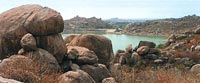
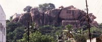
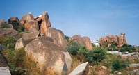
Rock formations around Shamirpet Lake, Shamirpet.
a) Venkateshwara Gutta highly recommended for rock outings, inspite of a water reservoir being built on the hill top. Extensive hillock with a temple in the rocks; many
possibilities for walking, climbing, bouldering; highly
recommended for rock outings. ~ 30 km from St. Ann's High School, Secunderabad.
Coordinates (temple): 17°37'54" N 78°33'13" E
b) Deer Park A few impressive formations towards the lake side;
permission by Forest Department needed to enter the area.
Coordinates (Entrance): 17°35'55" N 78°33'30" E
c) Reserve Forest: Scattered impressive formations throughout the area.
Enlarge view | Routemap |
| 15. |
 |
Rocky Ridge behind Malkam Cheruvu, near Sheikpet.
High rock formations; not very extensive; difficult access, only for the adventurous.
Coordinates: 17°24'57" N 78°22'54"E
Enlarge view | Routemap |
-----------------------------------------------------------------------------------------------------------------------
3 Sites had been proposed in the Secunderabad Cantonment area and, Since not under HMDA (formely HUDA) Jurisdiction, have to be protected by the Cantonment administration.
----------------------------------------------------------------------------------------------------------------------
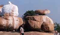
Citizens' Initiatives for Preservation
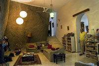
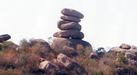
Citizens have taken their own steps to express their love and admiration for our granite rocks by preserving rock formations in their properties, even inside their houses.
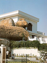
|
Narendra Luther's Wall of Rock in his house in Banjara Hills.
Enlarge view
|
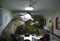 |
N. Luther's Rock extends into Rahul's Flat on the first floor of the house.
Enlarge view |
 |
Rock in Road No. 32, Jubilee Hills
Enlarge view |
| The gods like to dwell in or on the rocks. One can find innumerable shrines, from small one-stone places of worship to big temples in and amongst many rocks, and dargahs and chillas as well. |
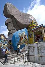 |
Mahakali Temple in Golconda Fort, built into the rocks
Enlarge view |
Also, more and more landscaped rock gardens are emerging near company buildings who are aware of the great asset they possess in the beautiful natural rockscape around them.
|
|